Field activities
Il progetto S4A prevede lo svolgersi di campagne di misura come parte integrante delle attività del progetto. Gli obiettivi delle attività di campo sono:
- fornire misurein situ utili alla calibrazione ed alla validazione dei metodi sviluppati soprattutto da WP2 SPACE;#testare il prototipo di workflow sviluppato dal progetto ed, in particolare, da WP5.
Il primo obiettivo risponde a necessità puntuali di verifica delle metodlogie proposte e/o sviluppate nel progetto; queste attività inizieranno nel 2014. Il secondo obiettivo mira a testare in modo combinato ed integrato i metodi proposti. Questo sarà oggetto soprattutto delle attività di campo del scondo anno di progetto (2015) che prevederanno:
- l'acquisizione di misure di campo con tecnologie smart;*l'acquisizione di dati da SAPR;
- L'acquisizione di dati da satellite che integrino le attività dei tre WP: SPACE, AERO, e IN SITU.
These activities will be carried out in 2015 in a study area located in Southern Lombardy (more details on the geographic location of the farm sites will be given) where selected farms will host the project's partners in 2014 and 2015.
Contents
FIELD CAMPAIGNS 2014
In 2014 field campaigns will be carried out during the entire season with the objective of monitoring field parameters useful for modelling the SAR backscatter signal in SAR images over crop areas (mainly rice and maize fields). Field activities will be coordinated and carred out by IREA-CNR.Objectives
The field campaigns have multiple level objectives in the research lines at the IREA-CNR:
- to collect in situ data on the crop biophysical parameters that influence both the optical and radar signal;
- to investigate modelling of the SAR signal;
- to refine/test pre-processing tools of the SAR data;
- to compare X-band images acquired by different SAR sensors (COSMO.SkyMed e TerraSAR-X);
Study area
TO BE DEFINED
Satellite data
Satellite data acquisitions will be acquired simuoltaneously to the field campaigns, as much as possible. Optical and SAR data will be acquired: Landsat OLI, Terra SAR X and Cosmo skyMed.
Field measurements
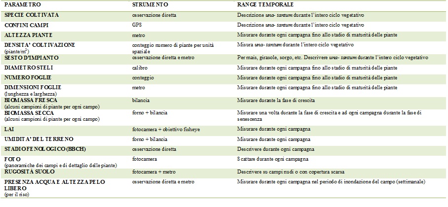
All the parameters that at the moment are foreseen to be acquired are listed in the table, which will be updated during the season. As a general approach, detailed measurements will be carried out on a small number of sites and more speditive/quicker measurements will be carried out at a regional scale.

