Difference between revisions of "Summary:"
Dstroppiana (Talk | contribs) |
Dstroppiana (Talk | contribs) |
||
| Line 24: | Line 24: | ||
: i) Development of digital augmented reality environments to provide information not readily available in support of UAV mission operator; | : i) Development of digital augmented reality environments to provide information not readily available in support of UAV mission operator; | ||
| − | : ii) Definition of protocols to integrate information stemming from different virtual environment instrumented systems; iii) Testing of prototypes for real time mission re-planning by acquiring experimental data in case studies of agricultural interest. | + | : ii) Definition of protocols to integrate information stemming from different virtual environment instrumented systems; |
| + | |||
| + | : iii) Testing of prototypes for real time mission re-planning by acquiring experimental data in case studies of agricultural interest. | ||
==IN SITU== | ==IN SITU== | ||
Revision as of 11:26, 28 February 2014
The project “Space4Agri - Sviluppo di Metodologie Aerospaziali Innovative di Osservazione della Terra a Supporto del Settore Agricolo in Lombardia” finds its justification in two different but complementary fields. On the one hand, it meets the challenge of Aerospace Earth Observation for the development of downstream services that, according to the indications provided within the European program GMES - Global Monitoring of the Environment and Security (now Copernicus), bring added economic value to business and benefits for public administrations and citizens. On the other hand, the proposal stems from the recognition of a need expressed in different contexts from DG Agricoltura di Regione Lombardia (e.g. Workshop “Agrispazio Space Application Contest 2012”, Milano 29/11/12) and shared with ARPA Lombardia; both call for the development of a framework of common knowledge to support the planning and management in the Agrifood sector of Lombardy, favouring sustainable development able to face climatic changes and to cope with challenges brought about by globalization. The project aims are in line with European policies and meet the Expo 2015 objectives. They are also in agreement with Horizon 2020 that specifically mentions food security and sustainable agriculture among its strategic issues and seeks to promote research that will result in innovative products and services offering business opportunities and improving the lives of citizens.
The purpose of Space4Agri is to take advantage in an innovative way of the advances in the following sectors:
- the recent developments in aerospace technologies for Earth Observation (EO), making available a large amount of satellite data with different spatial and temporal resolutions, which will be even greater with the advent of ESA Sentinel missions
- the frontier technologies of aeronautic such as Unmanned Airmobile Vehicles (UAV)
- the pervasive availability of sensor observations and smart technologies that involve citizens in the data/information cycle.
The overall aim is to meet the demand of consistent and updated information from the agricultural sector in Lombardy, that had to deal with unexpected critical situations causing the decrease in maize production for the year 2012 (- 20% with respect to 2011) with sensitive impacts on the entire agro-livestock of the Po Valley. Another innovative feature is the use of Web 2.0 technologies and methodologies for acquiring information directly from sensors (i.e. agrometeo stations) and in situ observations made by sector specialists (e.g. farmers, associations, consortia) and to return information / value-added services to regional decision-makers and agro-business operators via Web or mobile devices. The use of such technologies is guided by the awareness of the heritage of widespread local knowledge in the agricultural sector of Lombardy Region and by the need to integrate field data and remote observations in order to provide value added information on a regional scale.
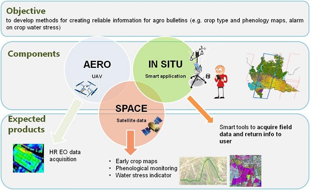
The expected results are intended to identify and fix the weaknesses of the data-information-service chain through innovative solutions, and can be referred to three specific areas for Aerospace Earth Observation: SPACE, AERO and IN SITU.
SPACE
- i) Development of methodologies for the creation of maps at the beginning of crop season by integration of optical radar satellite data;
- ii) Production of indicators for crop status and development and estimation of phenological stages on a regional scale through the analysis of satellite data time series;
- iii) Evaluation of indicators of crop water stress through joint analysis of satellite data in the reflection and thermal range.
AERO
- i) Development of digital augmented reality environments to provide information not readily available in support of UAV mission operator;
- ii) Definition of protocols to integrate information stemming from different virtual environment instrumented systems;
- iii) Testing of prototypes for real time mission re-planning by acquiring experimental data in case studies of agricultural interest.
IN SITU
- i) Design and demonstration of a data infrastructure for managing and sharing instrumented sensors measurements (Sensor Enablement) and agronomic existing database;
- ii) Development of smart technologies for the acquisition of in situ observations from operators of the agricultural sector;
- iii) Development of smart technologies to feed back information to regional and local agriculture specialists/ users.
