Difference between revisions of "Field activities"
Dstroppiana (Talk | contribs) |
Dstroppiana (Talk | contribs) |
||
| Line 26: | Line 26: | ||
===Field measurements=== | ===Field measurements=== | ||
All the parameters that at the moment are foreseen to be acquired are listed in the table, which will be updated during the season. As a general approach, detailed measurements will be carried out on a small number of sites and more speditive/quicker measurements will be carried out at a regional scale. | All the parameters that at the moment are foreseen to be acquired are listed in the table, which will be updated during the season. As a general approach, detailed measurements will be carried out on a small number of sites and more speditive/quicker measurements will be carried out at a regional scale. | ||
| + | |||
| + | [[Image:tabella_misure2014.jpg|center]] | ||
Revision as of 16:00, 3 March 2014
The Space4Agriproject forsees field activity as part of the work to be carried out. The objectives of the field activities are:
- to provide field measurements useful for calibration and valdation of the methods mainly developed by WP2 SPACE;
- to test the prototype developed for the project as part of the tasks of WP5;
The first primarily addresses punctual topics whithin the methodologies proposed and eveloped in the project; these field activities will be carried out in 2014. The second part mainly aims at the combined and integrated test of the developed methods. This test t be carried out in the second year of the project foresees the acquisition of field measurements (traditional netwrok and smart technologie), the acquisition of UAV images, the acquisition of satellite data which integrate the activity of the three WPs of the project: SPACE, AERO, and IN SITU. these activities will be carried out in 2015.
The field activities will be carried out in a study area located in Southern Lombardy (more details on the geographic location of the farm sites will be given) where selected farms will host the project's partners in 2014 and 2015.
Contents
FIELD CAMPAIGNS 2014
In 2014 field campaigns will be carried out during the entire season with the objective of monitoring field parameters useful for modelling the SAR backscatter signal in SAR images over crop areas (mainly rice and maize fields). Field activities will be coordinated and carred out by IREA-CNR.
Objectives
The field campaigns have multiple level objectives in the research lines at the IREA-CNR:
- to collect in situ data on the crop biophysical parameters that influence both the optical and radar signal;
- to investigate modelling of the SAR signal;
- to refine/test pre-processing tools of the SAR data;
- to compare xband images acquired by different SAR sensors (COSMO-SkyMed e TerraSAR-X);
Study area
TO BE DEFINED
Satellite data
Satellite data acquisitions will be acquired simuoltaneously to the field campaigns, as much as possible. Optical and SAR data will be acquired: Landsat OLI, Terra SAR X and Cosmo skyMed.
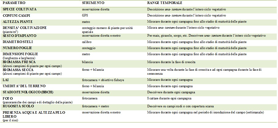
Field measurements
All the parameters that at the moment are foreseen to be acquired are listed in the table, which will be updated during the season. As a general approach, detailed measurements will be carried out on a small number of sites and more speditive/quicker measurements will be carried out at a regional scale.

